BhuCarbon
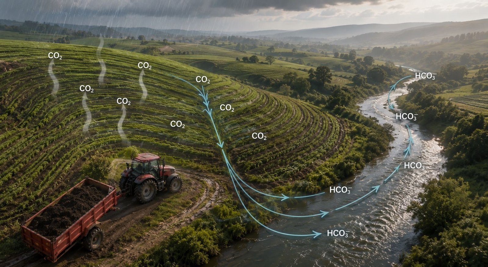
Aerial view of contour-ploughed hillside farmland under rain, a tractor towing a trailer of crushed basalt along the field edge, and a river running through the valley below. Annotations trace CO₂ moving from the air into the soil and leaving as bicarbonate carried downstream.

Method

The science, including the parts that are hard for us.

Enhanced rock weathering is simple chemistry applied to complicated ground. This page sets out the mechanism, the measurement, and the conditions under which it works badly.

01 · The mechanism

The mechanism

Silicate minerals react with carbonic acid — rainwater that has dissolved CO₂ from the air. The reaction breaks the mineral down, releasing calcium and magnesium and converting the dissolved CO₂ into bicarbonate. This is the process that has regulated atmospheric carbon over geological time, and it is the largest natural carbon sink there is.

Its limitation is rate. Weathering is governed by the surface area of rock exposed to water, and intact bedrock exposes very little. Crushing basalt to a fine particle size raises that surface area by orders of magnitude; spreading it across cultivated soil places it where water, root exudates and biological acids are already concentrated. The chemistry is not modified. Only the speed is.

What makes the removal durable is where the carbon ends up. Bicarbonate is stable in solution and, on reaching the ocean, remains part of the marine inorganic carbon pool on a timescale of tens of thousands of years. That is a different class of claim from carbon held in biomass or topsoil, which can be released by a fire, a drought, or a change in how the land is farmed.

  1. 01

    Basalt is spread

    Finely crushed silicate rock is applied to farmland at agronomic rates, using the equipment and calendar farmers already work to.

  2. 02

    Rain dissolves it

    Rainwater carrying dissolved atmospheric CO₂ forms a weak carbonic acid. It attacks the rock grains, releasing calcium and magnesium.

  3. 03

    Carbon becomes bicarbonate

    The reaction converts CO₂ into dissolved bicarbonate — a stable, aqueous form, no longer a gas and no longer in the atmosphere.

  4. 04

    Rivers carry it to the ocean

    Bicarbonate drains to the sea, where it is stable on a timescale of tens of thousands of years. This is the durability claim.

The reaction CaSiO3 + 2CO2 + H2O yields Ca2+ + 2HCO3 + SiO2

02 · Why India

Why India, why basalt

The Deccan Traps are one of the largest basalt provinces on the planet, and they sit beneath and beside a great deal of Indian farmland. Proximity matters more than it first appears: crushing and hauling rock costs energy, and that energy is subtracted from the removal before anything is credited. A short haul is not a logistics preference, it is a term in the net figure.

The agronomic case is just as specific. Large areas of Indian farmland are acidic and nutrient-depleted, and are treated with agricultural lime and increasing quantities of fertiliser. Basalt addresses acidity through the same reaction that captures carbon, and carries calcium, magnesium, potassium and micronutrients as it dissolves. Where that is true, the farmer has a reason to take part that does not depend on the carbon market existing.

Where it is not true, we say so. The next section is the honest version of that assessment.

03 · The five zones

India is not one soil.

Dissolution rate, agronomic benefit, and how hard the removal is to detect all change with the ground beneath the rock. We hold a separate interpretation model per agro-climatic zone, written and owned by the science team. Two of the five are hard cases for us, and they are listed as such.

Agro-climatic zones, their soil character, and the implication for enhanced rock weathering.
Zone Soil character What it means for ERW Standing
Red & lateritic Chhattisgarh · Odisha · Jharkhand · eastern MP Acidic, low cation exchange capacity, low base saturation, aluminium toxicity. Chemically the strongest target. Fast dissolution, and a large agronomic lift because the acidity ERW corrects is the same acidity suppressing yield. Strong fit
Indo-Gangetic alluvial Uttar Pradesh · Bihar · Punjab · Haryana Neutral to alkaline, calcareous, zinc-deficient, with sodicity pockets. High pH slows dissolution, so removal rates are lower. Requires ESP and SAR alongside free lime in the analyte set. Zinc is the deficiency farmers actually notice. Workable
Deccan Vertisols Maharashtra · Madhya Pradesh · Telangana High clay, high CEC, shrink–swell behaviour, already basalt-derived. Closest to the feedstock and cheapest to reach — but the weathering signal is weak against a high background of soil inorganic carbon. Detection, not chemistry, is the constraint. Hard case
North-eastern & Himalayan foothills Assam · Meghalaya · sub-Himalayan belt Acidic, high organic carbon, high rainfall. Weathering is fast, but erosion physically removes basalt from the plot before it fully reacts. That is a leakage-accounting problem, not a chemistry problem, and it has to be quantified rather than assumed away. Hard case
Coastal & saline Coastal Andhra · Gujarat · Sundarbans margin High sodium, high electrical conductivity. Sodium adsorption ratio and chloride join the standard panel. Salinity interacts with base cation measurement, so the baseline has to be denser here than elsewhere. Workable

Why publish the difficult ones. A methodology that works everywhere is a methodology that has not been tested anywhere. The Deccan Vertisols are the cheapest soils for us to reach and among the hardest to measure against — both facts are true at once, and a buyer evaluating this work needs the second one as much as the first.

04 · How we measure

How we measure

Every sample runs the same panel. The farmer-facing soil card and the carbon accounting are two readings of one physical sample, not two separate exercises.

Baseline
0–15 cm · 15–30 cm
Multi-depth and georeferenced, taken before a single tonne of rock is applied.
Total elemental
XRF
Whole-rock and whole-soil composition, not just the plant-available fraction.
Immobile tracer
Ti · Zr · Nb
Elements that do not weather, used as the denominator for depletion mass balance.
Exchange chemistry
CEC · Ca · Mg · Na · K
Base cations released by dissolution, and where they end up.
Conversion basis
Bulk density · texture
What turns a concentration into tonnes per hectare. Skipping it is how estimates go silently wrong.
Safety panel
Ni · Cr · V
Trace metals carried by basalt. A food-safety exposure, monitored as one.

Baseline before anything is applied

A georeferenced, multi-depth baseline is taken on every plot before a single tonne of rock is spread — at minimum 0–15 cm and 15–30 cm. This is the one step that cannot be recovered later. A plot sampled after application has no defensible before-state, and no amount of subsequent work repairs that.

Mass balance against an immobile tracer

Establishing how much of the applied rock has actually weathered requires a reference that does not weather. Titanium, zirconium and niobium are effectively immobile in these systems, so the change in the ratio of a mobile element to an immobile one gives depletion directly, without depending on knowing precisely how much rock reached a given square metre.

Concentration is not a quantity

Laboratory results arrive as concentrations. Converting them to tonnes per hectare requires bulk density and texture for the specific horizon sampled. Assuming a standard value here is a common and quiet source of error, so we measure it.

Uncertainty is an output, not a caveat

Every removal estimate is produced with its uncertainty propagated through the calculation rather than appended to it. A figure without an interval is not a measurement, and in carbon removal a confidently wrong number is worse than an honestly wide one.

05 · Safety

Safety

Basalt carries trace metals — nickel, chromium and vanadium among them. At the application rates used in enhanced rock weathering this is a manageable exposure, but it is a real one, on land that grows food, and it is not adequately addressed by assuming the levels are low.

Every feedstock lot is assayed for its trace metal content before it is approved for spreading, and the same elements are tracked in the soil panel afterwards. Lots outside threshold are not used. Alert thresholds are set by the science team, and are being finalised alongside the first field deployments.

06 · What we do not claim

What we do not claim

Bhu Carbon has not issued a carbon credit. We are pre-first-issuance, and the following are open rather than settled:

  • Registry pathway

    Under evaluation. Isometric and Puro.earth have materially different evidence requirements, and the choice affects the data model, so it is being made deliberately rather than quickly.

  • Removal figures

    None published. When they are, each will name the plots, the geometry version, the model version and the uncertainty interval behind it.

  • Third-party verification

    Not yet undertaken. It follows first issuance; claiming it before then would be meaningless.

  • Agronomic yield claims

    We report soil chemistry, which we measure. We do not attribute a yield figure to our intervention without the trial design to support it.

07 · Data integrity

Data integrity

An estimate that cannot be reproduced is an assertion. Everything below exists so that a removal figure can be recomputed, from its original inputs, years after the person who first ran it has moved on.

Field and lab records are append-only. Nothing is edited in place. A correction is a new record that supersedes the old one, and both remain. A mutable field record cannot be audited, and this is precisely what an auditor examines.

Plot geometry is versioned. Indian smallholdings are divided on inheritance, partially leased, and remeasured. Every measurement references the specific geometry version in force when it was taken, so a boundary change does not silently invalidate the history attached to it.

Provenance is recorded on every row. Who captured it, when, on which device, under which application version, and through which ingestion path — field capture, partner-lab import, or our own laboratory. When an auditor asks which results came from where, the answer is a query rather than a reconstruction.

Custody of the feedstock is chained. Quarry, lot, geochemistry, weighbridge, transfer, spread event. Each link is hash-chained to the one before it, so the record of what was applied where cannot be quietly revised after the fact.

Questions about the method are the ones we most want.

If you are evaluating this work — as a buyer, a researcher, or an auditor — write to the science team directly.